Broad Town History
History and memories of our community

If you're pressed for time the Project Summary below will give you a flavour of the key project findings. Alternatively, scroll further down this page to the Project Output section to read the more comprehensive official project deliverables. Keep scrolling further down for videos, photos, management reports and other research items. Right click on any image and select the more tools option to magnify the image.
Project Summary
The aim of the White Horse project was to establish the exact position / size of the current white horse and assess the following :
1) the topography of the white horse
2) the risk of landslip
3) the depth and differing layers of the chalk / liming infill for any evidence of its previous incarnations
4) the condition of the horse
5) the chronological development of the horse from 1900 to date.
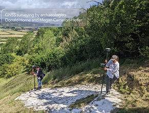
A number of experts were brought together to achieve the above project aims, namely, an archaeological geomatics specialist Donald Horne, a leading geoarchaeologist and environmental archaeologist Dr Michael J Allen and a prominent researcher/expert on White Horses Garry Gibbons.
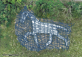
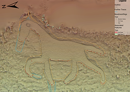
Donald Horne's Topographic survey very precisely measured the horse using the 300 points highlighted opposite. The survey also established the exact position / size of the current white horse.
The hillside surrounding the Horse (fondly called the hangings by the locals) is a slope measuring 32° at the brow to 47°. The horse sits on a slightly levelled area between 20-25° and is located at SU0987078279 (Easting:409878 Northing: 178279) measuring 25.3m in length and 19.1m in height (Measured in relation the slope).
As shown below the survey identified subtle features such as possible remnants of an earlier form e.g. elongation of the limbs, a potential ear, and remnants of a former head and legs. The survey also notes traces of a thinner earlier face within the current outline.
Topographic Report Fig. 33 : Page 34
Topographic Report Fig. 14 : Page 31

Topographic Report Fig. 15 : Page 10

Topographic Report Fig. 20 : Page 16
Dr Derek Greer's Landslip report indicates that the danger of land slips directly affecting the BTWH is real (as the whole escarpment has a higher than typical landslip risk) but to date the local landslips have occurred at higher inclines or at junctions of various geological layers, so immediate risk is moderate to low. Avoiding water build up in the fields above the horse and encouraging further research to include slope stabilization options (especially on inclines that exceed 35°) or soil/chalk moisture geophysics monitoring are potential next steps. Perhaps the most useful practical step which could be taken is to establish a panel of experts and local volunteers who could periodically review the state of the white horse and its close escarpment.
Dr Michael J Allen's Augur survey found evidence of chalk infill outside the area of the current horse suggesting that there is the potential for ears to have existed, a larger nose or different shaped head to exist and potential of a larger and different horse on site that is now completely grown over.
The Auger survey noted an axial line through the nave and chancel of Christ Church directly aligning with the horse and the Topographic survey noted that the school has
the least difference in aspect meaning it has a slightly superior view of the Horse.
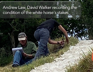
Garry Gibbons found the Horse to be in reasonably good condition. The main areas to be monitored are under the neck plus belly and at the base of all four legs.
Garry Gibbons's Chronological development research highlighted a number of anomalies and inconsistencies relating to each cut feature of the Broad Town white horse, namely the existence and size of the eye, the disappearance of the ear/s, the change in shape of the tail from bob to flowing, the neck and body are creeping downhill (resulting in the narrowing of the neck and body), the rump oscillating from rounded to straight, the outer front leg changing from a single bend at the knee to having a further bend at the fetlock (extending the leg to the single smooth curve we see today). The inner front leg has changed from a leg pointing vertically downhill to bending at the fetlock, shaping it under the body. The inner rear leg used to point vertically downslope, however, it has now acquired an angle at the knee, shaping the leg under the body. The outer rear leg used to be bent kicking out at the rear ( the lower half angled downhill), however, today we see a distinctive extended kick at the fetlock out to the rear starting to point downhill since the 1980’s

Auger Report (points surveyed in blue) Fig. 6 : Page 5

Chronological Development Report Marple's late 1930's survey compared to 2025 survey Fig. 18 : Page 13
There is no definitive account surrounding the cutting of Broad Town’s chalk horse and it is fair to say that all of the studies provide a foundation from which further work could emerge e.g. Auger the remaining 27 points (or more specifically points 34 and 33 and below the figure) or in light of the project findings new auger points, deepen the research into the chronological development especially pre-1900, further the research on the Hacker plan and association with both Broad Town & Broad Hinton’s horses etc
The White Horse Restoration Group can take certain findings forward for more immediate discussion e.g. should the tail be re-shaped into a bob tail, should the ears be reinstated, would the legs benefit from any re-shaping?
Broad Town extends its sincerest thanks to the following organisations and people :
R.D. Horton & Son for their permission to access the site for the surveys
The Broad Town White Horse Restoration Group led by Andrew Law (Chair) and Derek Greer (Secretary)
Donald Horne for the topographic activities and report
Dr Michael J Allen for the Augering activity and report
Gary Gibbons for the Chronological Development and Condition activities and reports as well as co-ordinating, participating and leading the project along with Andrew and Derek.
Matt Day, Bath University for the Broad Town White Horse slope dissertation
David Dawson, Director Wiltshire Museum for supporting and archiving the project results
Broad Town Parish Council for providing support and volunteer insurance
North Wessex Downs National Landscape, North Wessex Downs Landscape Trust and the Bluefield Solar Income Fund (Broad Town Community) for funding the various project activities.

Working on project activities
_JPG.jpg)
_JPG.jpg)

_JPG.jpg)
_PNG.png)
_JPG.jpg)
%20labelled%20(002)_JPG.jpg)
Items of General Interest
Drone surveying the horse
Drone animation of the 1947 photograph (original Source: Historic England Archive)
Project Management & Other Research
The Broad Town White Horse Restoration Group hold an archive of all project outputs. Please email broadtownwhitehorse@outlook.com if you would like to be forwarded any of the documents held in the below index of 'other' documents